

Skip the Store and Go Outside!
Below you will find some hiking suggestions for Black Friday, courtesy of Otto Specht School!
Start with the obvious one for this particular time of year…
long path and turkey hill pond
Fresh air and exercise are still vital parts of a healthy, balanced life for children and adults everywhere! This week, we are offering 3 options from one starting point so hopefully there is something for everyone here! Of course, with the warmer weather and too many months at home, more and more people will be heading out so remember to find off times to avoid crowded pathways and to better enjoy the solace and beauty nature can provide!
Starting Point: Turkey Hill Pond Parking
You will begin along the Long Path (teal blazes) but soon come to the start of another trail (white with red squares) heading off to the right, which is one of your options, taking you directly to Turkey Hill Pond.


If you follow this path ( 1 Option), be sure to notice where the red markers make a left turn that takes you on a decent but manageable downhill, eventually to the pond's edge.

Should you be inclined for an uphill to sweeping views, do NOT turn onto the red path and continue following the teal markers to your left and uphill.
Eventually, you have another choice to make: a quicker, more difficult scramble to the top (follow brown blazes to the right - Option 2) or a more manageable and meandering climb (stay to the left on teal - Option 3).


Either choice will lead you to the summit and beautiful views of Turkey Hill Pond and beyond to neighboring peaks.
With all of nature waking, pay close attention to all the flora and fauna you see along the way. Make a photo journal and/or list of the flowers, creatures, and other interesting sights along your way!
Silver Mine Lake to Stockbridge Shelter
This is a favortite of mine this time of year thanks to the pine forest that makes jingle bells ring in my head!
Silver Mine Lake has a large parking area off of Seven Lakes Dr. not far from the traffic circle intersecting the Palisades and Seven Lakes Dr. There are many trail options from here, but a quick, scenic route is described and pictured below.
Go to the right to park as you will follow the yellow blazes as they exit the far right side of the parking and picnic areas by the lake. The trail will head towards the road and run parallel for a moment, passing through the Lewis Cemetery. It will then CROSS seven lakes Dr.
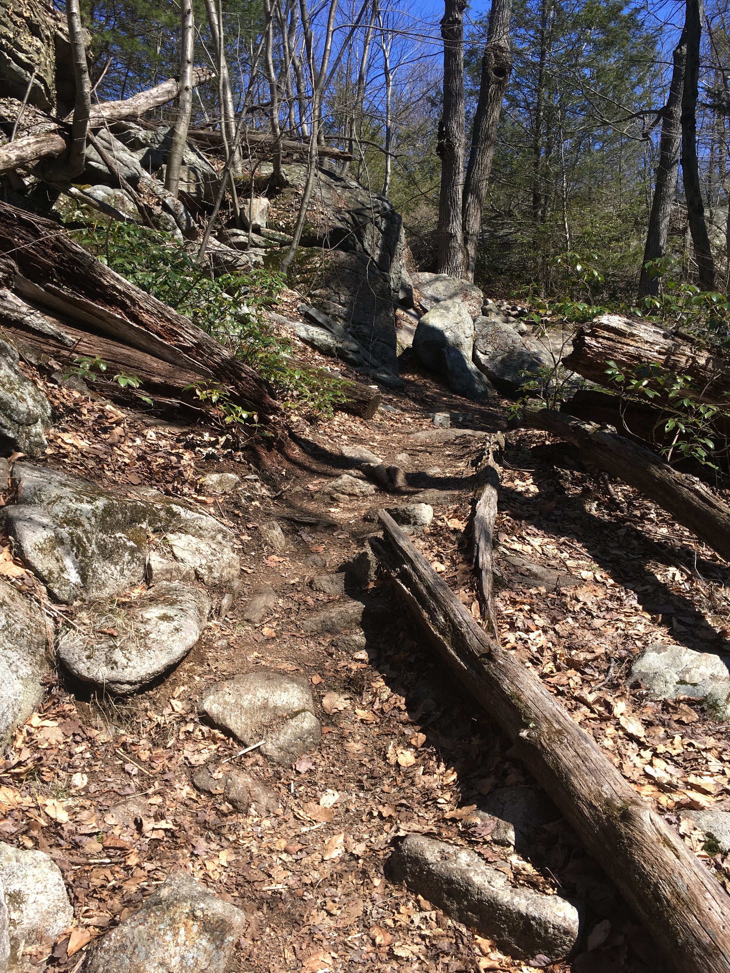
You will continue to follow the trail with the pond to your left and eventually come to a rock crossing (pictured below).


Eventually, the yellow trail ends. To your right and left, you will see the teal blazes of the Long Trail. Turn right to head up a fairly steep but lovely climb to the shelter.


Heading Out
From Lake to Shining Lake (Sebago to Wanoksink)
Park at Sebago boat launch and cross 7 lakes Dr. to enter the trail marked with blue squares on white.

Follow the blue square on white


2. Continue on this trail until after you cross the creek (take a moment to enjoy the small waterfall!). Soon, the blue on white blazes will take a sharp turn to the right - continue straight on the unmarked, wide path instead.

Enjoy the falls

Which bridge would Mrs. Macauley take?

Do NOT turn right here…
3. When the path T’s at an access road, turn right. You will soon see the lake through the trees to your left. Continue on and you will see the marsh at the base of the grassy retaining wall. Following the road to the left will bring you up to the lake. You can stay and relax on the large flat rock or continue to explore around the lake.

Lake Wanoksink

Trail by the Lake if continuing on in your explorations!

Another scavenger hunt item…
Heading Out
Doodletown!
This hike is ar popular Otto Specht School hike, often taken by 4th graders learning local history or middle schoolers learning about the Revolutionary War, or all students who enjoy a good hike with many points of interest. We suggest heading out on a weekday to avoid other hikers as much as possible. Warning: Beware of rattle snakes!
Park on Rt. 9W at Tompkins Cove
Cross 9W (carefully)
Option 1: Mine Too! (longer, more scenic woods)
Head off on the South side of the creek, following the blue blazes of the Cornell Mine Trail.
The trail heads uphill on a footpath, climbing rather steeply, then leveling off. To your right, you will be able to look down into the gorge of the Doodletown Creek, where you will soon be able to see the cascades of a small waterfall.
As the blue trail veers left, away from the falls, take the unmarked trail towards the falls. Here, the Doodletown Bridle Path crosses the top of the falls. Take a moment to enjoy the falls, then continue on the bridle path away from the falls.
Keep your eyes open to your left for “waste rock” on the side of the hill, an indicator of an old mine. A sign on a tree by the path will let you know you have found the Edison Mine. Head up the small hill to find the mine (see picture below).
Continuing along, you will pass a marsh and eventually come to the “1777” trail. Turn right to follow this trail (marked with white circular tags with 1777 in red) into Doodletown.
Along the way, you will see markers for many sites of homes and businesses from the once thriving hamlet. Explore a bit!
When you reach the reservoir, bear left, skirting around the reservoir. This road is quite wide and will lead on past more turn offs should you wish to explore, and will eventually lead right back down to 9W where you began, only now you will be on the north side of the creek.
Option 2: Straight to Doodletown
If you prefer to have a more relaxing stroll through the town and do not need the jaunt in the woods, head to your right (north side of Doodletown Creek) from 9W. This will climb up for a bit but will soon level out into town. This is the route taken by the Otto Specht Students in the image below (heading straight to Doodletown).

Heading straight to Doodletown (OSS all school hike, 2015)

Lunching at the June Cemetery (OSS all school hike, 2015)
The History of Doodletown: A Short Essay by Zachary Pace
As Mrs. Chin and I walked through Doodletown, we walked past the famous eight foot deep swimming hole that was now only about five feet. This once self sufficient flourishing town, named Doodletown, is now overgrown with trees, brambles, vines, and briars. Only the roads, the Doodletown reservoir, the foundations of the old buildings, and three old cemeteries are sort of accessible. The oldest cemetery which is near Lemmon road and on Ethiel Junes homestead is overgrown with barberry and other under growth. It’s head stones as the park was being founded, were taken out in order to build the Doodletown bridle path which is now a ski path.

Just downstream from the waterfall (OSS 2015)

Edison Mine
The town was started by woodsmen clearing plots for homesteads and later on in the 19th century it morphed into a bustling town with its residents working on Iona Island or Bear Mountain. otherwise everything they made; the meat they dried and smoked, the vegetables were canned for winter. In the winter they cut ice from Rockland lake and sold it in the spring. In this town there were only 18 families total, one school that turned into a Methodist church on Sundays and a store. No one knows exactly how Doodletown got it’s name but here is what my book says, it is a combination of two Dutch words “dood”, meaning DEAD, and “dell”, meaning valley. Although it looks like the name now, you could see how it was once great and why 18 families chose that place to live. One of the views looked like it came from a fairytale.
Although the last homeowner left in 1965 it is still a good place to go for a hike.

Bald Rocks Shelter
~2.25 miles
Park in the Lake Skannatati parking lot.
Take the Long Path (Teal Blaze) for approximately 1 mile
Then take a left on the Dunning trail (Yellow Blaze) for approximately 1.5 miles
The shelter will be on a woods road on the left.


Heading Out
A Long Path or Short Road from St. John’s in the Wilderness
Another absolute favorite for Otto Specht School students
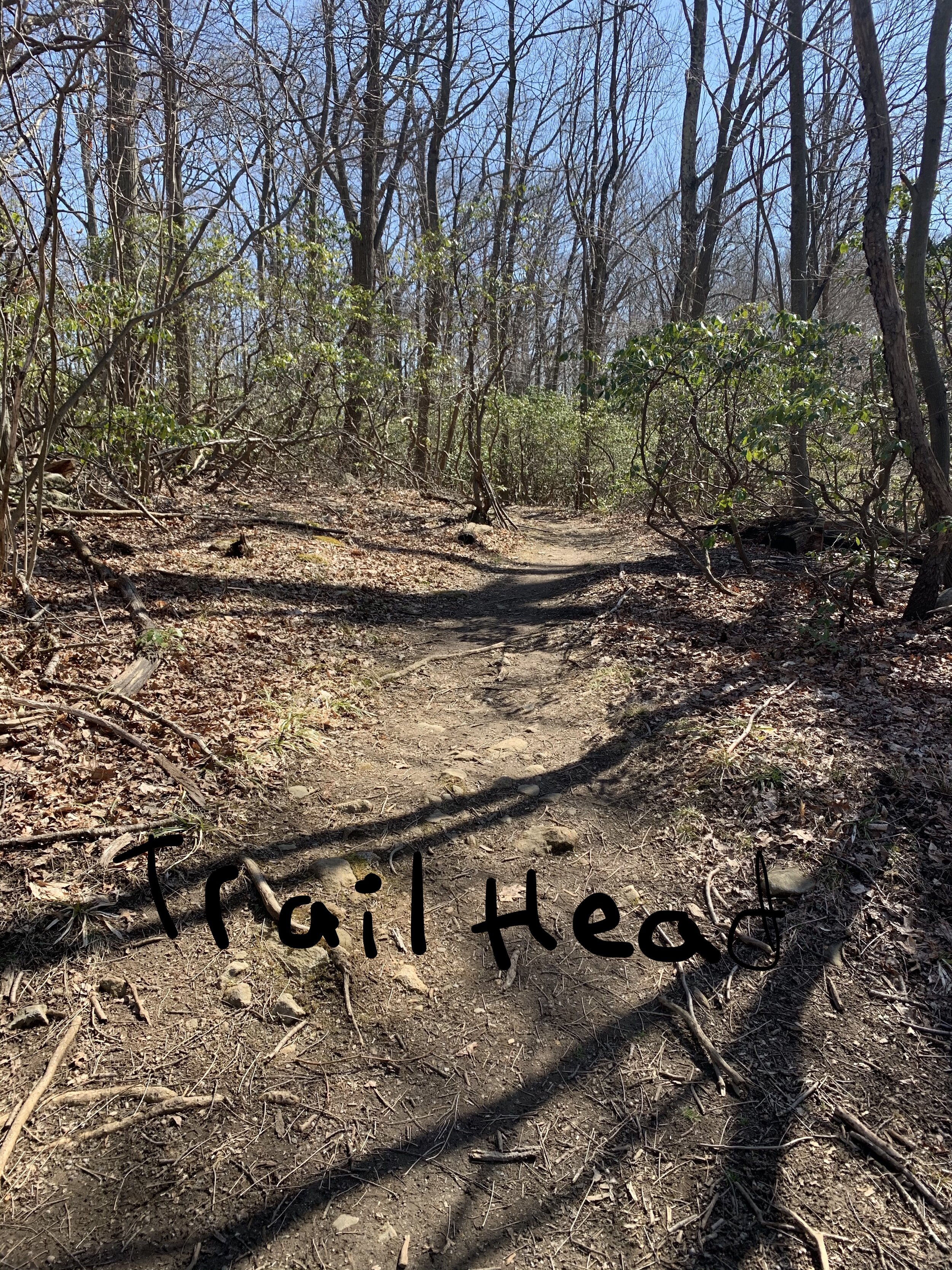
Trail Head

Look for water birds in the scenic marsh to the right

Scenic Marsh

Historic Marker/Memorial
Option 1: Full Loop (some difficulty, longest)
Option 2: To the lookout and back (moderate difficulty and length)
Option 3: Straight to the Lake (easy and short)
Follow Green (Aqua) blazes that mark the “Long Path”
Pay attention to the blazes guiding you left despite a clear path straight (for option 3, continue straight - from here you will turn left on the road - and follow it into the Appalachian Mountain Club where you will find the lake - spend time here and head home!)
Stay on aqua blazes - you will pass a historical marker/memorial for Flight 6231 and its captain, John B. Lagorio.
The trail continues on, a full array of Harriman Park scenes - hills, dales, creeks, glacial rocks, moss, and more.
Eventually, you cross an access road - continue on the trail, straight across
At the top of the hill, you will find the lookout (see pics from Otto Specht School all school hike circa 2016). From here you can see the Hudson River to your left and Manhattan to your right. For option 2, stay a while and then return the way you came.

Trivia for Marshmallows

Mr. Leopold Entertaining as Usual
To complete the loop, find the yellow blazes (to your right if looking out at the views). This trail traverses the ridge, and eventually you will see Reservoir number Three below you to your left. Look for an unmarked trail heading off to the right once you have nearly passed the reservoir (below). Turn right and continue to go right as you see crossings. You may see white blazes going nearly parallel for some of this, but you need to follow the path as it turns right and soon descends. You will see a lake below and to your left. The descent is rather steep - this is the only challenge on this hike. At the bottom of the hill, you will turn right into the Appalachian Mountain Club. Here, I recommend taking a moment to enjoy the lakeside docks and “beaches.” When you are ready to leave, continue in the direction you were heading, following the main road. You will soon come to a paved road. Continue on until you pass the access road on your right. Look for the next trail entrance on your right (see pictures). Enter this trail and soon it will meet back up with the Long Trail (aqua blazes) and will take you right back to St. John’s.

Follow Yellow Blazes to continue the loop

Unmarked trails to the right soon give way to lake views

A Steep Descent with Lake to the left
Through the Mountain Club

Beach

Intriguing trees on the road back

Go past this…
The way back (turn right here)
Sing While You Hike!

Go Ahead! Get outside, and see what you see along the way.

Wintergreen Berries

A tree with a heart

Candyland the Dinosaur